
MOUNT KINABALU
The Summit of Borneo
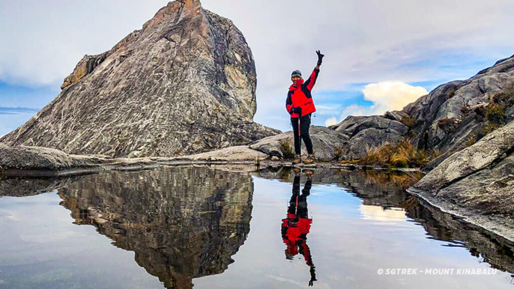
Mount Kinabalu is the most dramatic feature in Sabah and the tallest peak between the Himalayas & the New Guinea. Towering at 4,095 metres (13,435 feet), Mount Kinabalu exerts a magical quality that is both indescribable and unbelievable. The granite peaks are constantly veiled in wisps of clouds which sometimes resemble a graceful woman peeping coyly from behind the veil. At times during a clear day, the summit reveals a distinct glacier carved pinnacles, rising from the smooth granite dome, exuberating tranquility and peacefulness.
The mountain itself represents one of the world’s youngest batholiths: an old magna chamber that was forced through the earth’s crust. Though young, it is the central focus of Kinabalu Park and the legends of the KadasanDusun people, Sabah’s largest ethnic group. The KadasanDunsun believe that the mountain is the sacred resting ground of the spirits of their ancestors.
 Legends & Myths – Mt Kinabalu Tale
 Legends & Myths – Mt Kinabalu Tale
There are many folklores and fables that tell stories of how Kinabalu got its name. The local KadazanDusun people believe that the word is derived from “Aki Nabalu”, which translates into “revered place of the dead”. The mysterious KadazanDusun tribe believes that spirits dwell on the mountain top. According to another popular folklore, the name Kinabalu actually meant “Cina Balu”. “Cina Balu” translates into “chinese widow”. Legend tells a story of a Chinese prince who ascends from the mountain in search of a huge pearl guarded by a ferocious dragon. He married a Kadazan woman upon his successful conquest, whom he soon abandoned for return to China. His heartbroken wife wandered into the mountains to mourn whereby eventually she turned into stone.
CLIMBING MOUNT KINABALU
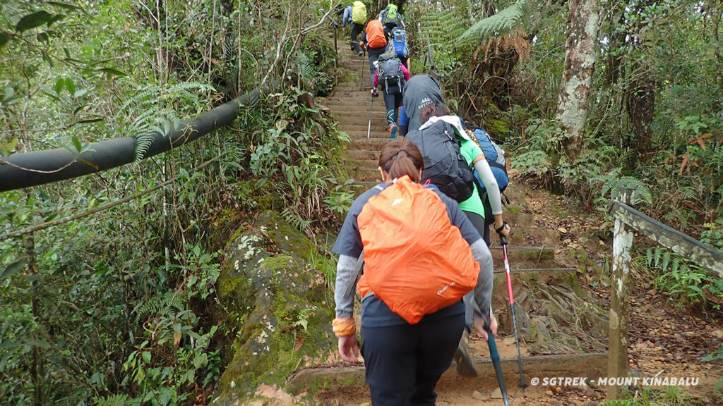
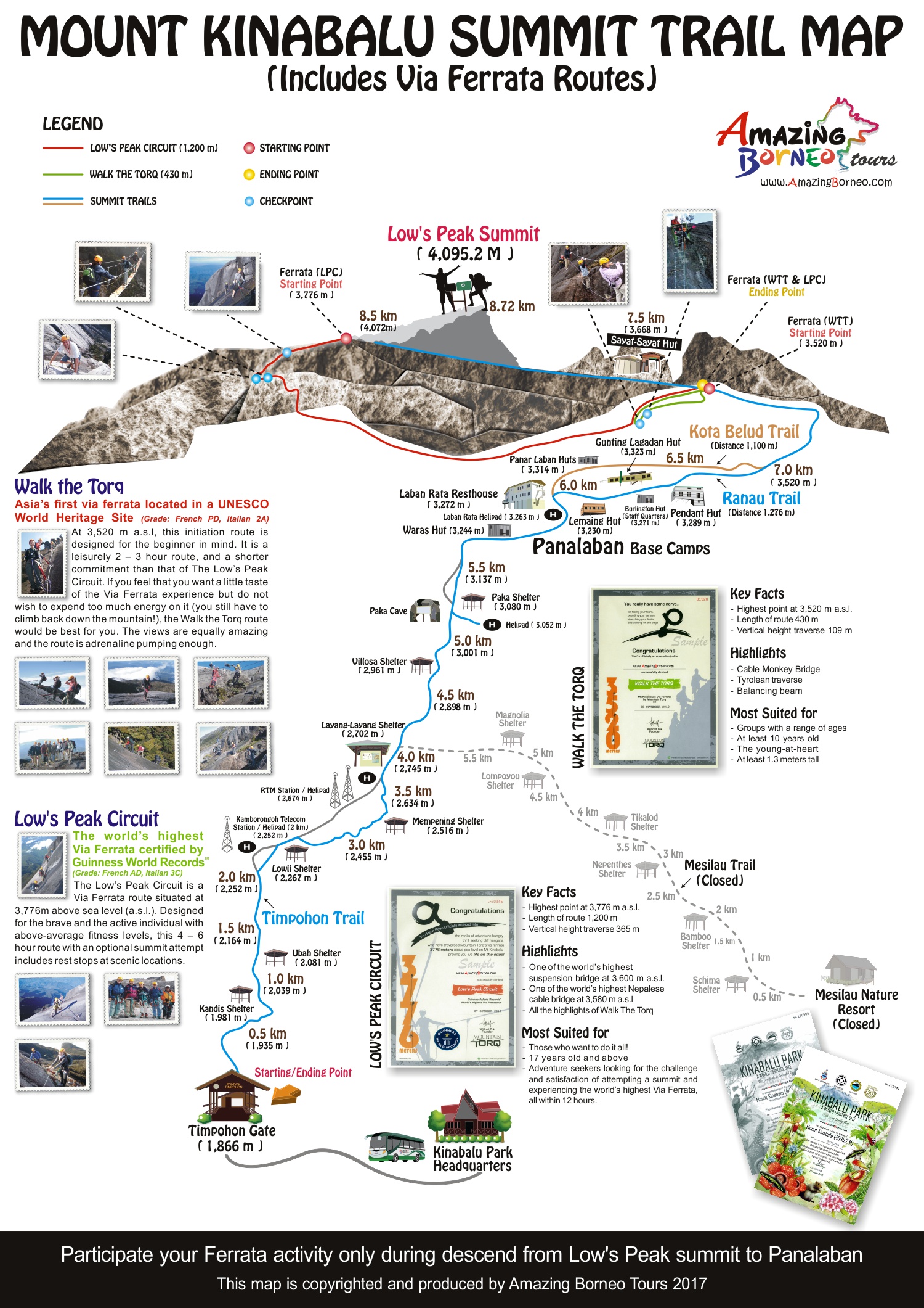
Ascending Mount kinabalu requires no specialized mountain climbing skills but it pays to be fit. Locals begin climbing the mountain from the age of three. The trail to the highest peak winds along the southern side of the mountain. It is an 8.5 kilometre (5.25 miles) trek to the top. For most people, from a 9 month-old baby (carried by father) to an 83 years-old New Zealander, the journey takes two days. However, champion mountain runners at the annual Mount Kinabalu International Climbathon, proclaimed the “toughest mountain race in the world”, have been known to complete the run up and down the mountain in less than 3 hours!
 The terrain stretches upward from lowland rain forest to montane forest, cloud forest and sub alpine meadow, before finally reaching a crown of bare granite. Only at Mount Kinabalu can you eat breakfast in a lowland rainforest, lunch in a cloud forest, and enjoy dinner in a subalpine meadow!
TIMPOHON TRAIL (4KM)
|
Timpohon – Summit Trail
The trail winds up a steep staircase of gnarled tree-roots to a mossy world of drifting clouds and orchird-draped trees, where where pitcher plants and rhododendrons abound. There are several shelters (or Pondok). The first is Kandis Shelter at 1,981.7 m, where on a clear day, a view of the road that links Kota Kinabalu city to the Park can be seen.
The second is Ubah Shelter at 2,081.4 m, the area where one of Borneo’s most unusual pitcher plants grows – the Nepenthes lowii, so do remember to look out for these oddly-shaped plants with containers. The mossy forest continues on past the Sabah Telecoms Station at Komborongoh, (2,252.2 m). Interestingly, ‘Komborongoh’ is a type of plant used to ward off evil spirits during traditional ceremonies and rituals by locals.
The third is Lowii Shelter. The trail continues up the mossy forest of mixed bamboos and tree ferns. More rhododendrons are seen. At 2,518 m is the fourth shelter, Mempening Shelter has wild begonias growing nearby. You can stop at these shelters to observe the squirrels, tree shrews and birds that seem so unafraid of climbers. Soon after the Layang-Layang TV station, you will emerge to an open exposed ridge at Layang-Layang (previously known as Carson’s Camp).
From Layang Layang, the journey upwards passes the fifth shelter, Villosa Shelter, at 2,690 m, which is situated at the top of an open rocky patch and soon the forest becomes even more stunted. Superb view can be seen of Mt. Kinabalu towering above you as you follow the trail upwards. As you climb higher, you will pass a forest of bent and twisted silvery-grey trunks with peeling bark.
At the top of this open area at 3,050 m, a small track leads off to a helipad on the right where you can catch a magnificent view of the Summit Plateau. Further on, you will come upon the sixth shelter, Paka Shelter, at 3,080 m. Look around for Paka Cave, which is sited on the edge of a small stream, and it is nothing more than a large overhanging rock where the first explorers slept.
The thinning air makes it harder to breathe. Finally, the various accommodations for overnight stop are reached. The accommodations include Waras Hut, Panar Laban Hut, Gungting Lagadan Hut, Pendant Hut and Laban Rata resthouse. You will break the journey and spend the night in one of these huts, which offer climbers hostel accommodation and a restaurant for hot meals before they resume their climb to the peak.
Panar Laban – ‘the place of sacrifice’ – was where Sir Hugh Low and his local guides performed a ritual sacrifice to appease the ancestral souls for their ‘disturbance’ to the spirit world and to seek safe passage. This same sacrifice is still performed each year and when there is a major expedition or event on the mountain.
Continue Climb to the Peak at 2:00am
 Continue Climb to the Peak at 2:00am
After a short night’s rest, you will need to be ready by about 2:00 am in the early morning in order to catch the sunrise at the peak. It takes about 3 hours depending on fitness level to reach the peak and there are ladders and ropes to help you over the steeper terrain. In the dark, you can see the beams of torch lights as the procession of climbers trudge higher and higher. Along the trail to the summit, marvel at the incredible mountain backdrop of teeth and fangs, rugged landscape of cliff, gorge, gulley, plateau and precipice and whatever you name it, the mountain has it!
An hour from Panar Laban, you’ll see the Sayat-Sayat Hut (3,668m), this is the highest shelter on the mountain. Your permit will be checked once again at this Sayat-Sayat Checkpoint for access to the summit and to ensure you will get your coloured climber certificate at the end of the climb. From here, you will walk across bare granite slabs that stretch endlessly ahead, in an eerie moonscape of stone.
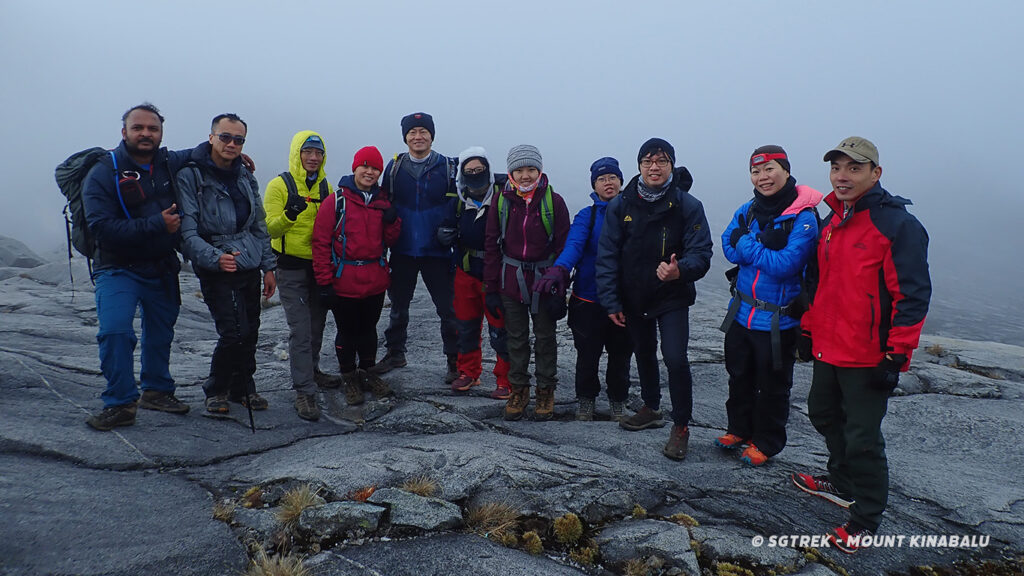
At 4,095.2m above sea level and in the freezing darkness, you reach your final destination – the summit of Mount Kinabalu. In an almost sacred manner, the dawn of a new day unfolds gloriously before you. It is a guaranteed awesome and magical moment of your life! From this vantage point, you’ll see a dramatic drop more than 1,000m down, this is Low’s Gully.
Descent to the Foot of Mountain
It can be very cold with strong wind at the summit. Hence, climbers are advised to descend as soon as possible. You may be lucky to have good mountain condition and able to stay longer. It is however advisable to descent before the swirling clouds could obstruct visibility. It takes about 2 hours to descent to Panalaban Base Camp and after you check out of your accommodation, it takes another 4 – 5 hours to descent to Timpohon Gate. The slowest descent record from Panar Laban to Timpohon Gate is 12 hours!
Types of Mt Kinabalu Climbers Certificate
It can be very cold with strong wind at the summit. Hence, climbers are advised to descend as soon as possible. You may be lucky to have good mountain condition and able to stay longer. It is however advisable to descent before the swirling clouds could obstruct visibility. It takes about 2 hours to descent to Panalaban Base Camp and after you check out of your accommodation, it takes another 4 – 5 hours to descent to Timpohon Gate. The slowest descent record from Panar Laban to Timpohon Gate is 12 hours!
Kinabalu Park Accommodation
 Kinabalu Park Accommodation
Kinabalu Park accommodation offers a variety of options to suit all budgets ranging from super luxurious private chalets to comfortable dormitories and suites.
Chalets and suites are equipped with excellent amenities and locally crafted, rustic furniture. Guests can relax in peaceful, picturesque surroundings or snuggle up beside the fireplace on cooler nights.
| Rock Twin Share | 4 Units | Common Lounge, Common Bathroom, Pantry |
| Rock Hostel | 20 Beds | Fireplace, Common Lounge, Common Bathroom, Pantry |
| Grace Hostel | 20 Beds | Fireplace, Common Lounge, Common Bathroom, Pantry |
| The Hill Lodge | 10 Units | Attached Bathroom, Heated Shower |
| Liwagu Suite | 4 Units | 1 Bedroom, 1 Bathroom, 1 Toilet, Living Area, Heated Shower |
| The Peak Lodge | 4 Units | 2 Bedrooms, Dining & Living Area, Fireplace, Bathroom, Pantry, Heated Shower |
| Summit Lodge | 1 Unit | 2 Bedrooms, Dining & Living Area, Fireplace, Bathroom, Kitchen, Heated Shower |
| Garden Lodge | 1 Unit | 2 Bedrooms, Dining & Living Area, Fireplace, Bathroom, Kitchen, Heated Shower |
| Nepenthes Lodge | 8 Units | 2 Bedrooms, Dining & Living Area, Fireplace, Bathroom, Pantry, Heated Shower |
| Kinabalu Lodge | 1 Unit | 3 Bedrooms, Dining & Living Area, Fireplace, Bathroom, Kitchen, Heated Shower |
| Rajah Lodge | 1 Unit | 3 Bedrooms, Dining & Living Area, Fireplace, Bathroom, Kitchen, Heated Shower |
Activities within Kinabalu Park
Visit Mount Kinabalu Botanical Garden (Mountain Garden) One of the biggest attractions at Kinabalu Park, this 5-acre Garden is an excellent showcase of the diverse plant-life on the mountain, as flora from all over the Park has been replanted here. Many of these plants are not only lovely to look upon, but have medicinal value too, as proven by the local Dusun community.
Guided Trekking
Follow any of the numerous and interesting nature trails within Kinabalu Park and discover rare and endemic plants today! Follow Park Naturalists or our guide as they take you on a guided trail walks and educate you on the various wonders.
| Liwagu Trail | 5620 | 2 hours |
| Silau Silau Trail | 3057 | 1 hour 30 minutes |
| Bukit Burung Trail | 1082 | 1 hour |
| Kiau View Trail | 2544 | 1 hour 30 minutes |
| Bundu Tuhan View (Sunset) | 465 | 15 minutes |
| Pandanus Trail | 598 | 20 minutes |
| Bukit Ular Trail | 997 | 30 minutes |
| Mempening Trail | 2516 | 1 hour 30 minutes |
| Bukit Tupai Trail | 345 | 15 minutes |
Important Notice : Guests wishing to trek along these trails must be accompanied by either a Sabah Park Ranger, a Park Naturalist or a licensed Tour Guide. We will not be held responsible for any death, injuries, loss and/or damage howsoever caused to trekkers. All guests trek at their own risks.
- Liwagu River TrailDistance : 5,620 metres
Duration : 2 hoursThe trail starts from Kinabalu Balsam Restaurant located at the Park Headquarters. The trail leads to Silau-Silau but does not cross until the Liwagu junction. Follow the Liwagu upstream before reaching the Power Station road near Timpohon Gate. It is a steep, narrow and varied trail through a ridge forest, cool stream valley, rattan palms and Liwagu. - Silau SilauDistance : 3,057 metres
Duration : 1 hour 30 minutesFollow the river from its source below Kiau Gap which junctions with the Liwagu River near the overhanging rock of Liwagu Cave. The trail is linked with other trails at various points, including Bukit Burung, Bukit Tupai and Kiau view. - Bukit Burung TrailDistance : 1,082 metres
Duration : 1 hourStart from the road, cross the Silau-Silau stream and trail, then proceed up the ridge side to Bukit Burung shelter for a spectacular view of the Park Headquarters, Lower Liwagu Valley and Mount Kinabalu. Attractions include easy access to a hill forest, cool stream valleys and dry ridge tops. - Kiau View TrailDistance : 2,544 metres
Duration : 1 hour 30 minutesFrom the arch at the park entrance, proceed along a wide undulating ridge trail. Finish just after the 1.5 km mark along the Power Station Road opposite the entrance to Silau-Silau Trail. Attractions include scenic views of the west coast and an assortment of local tree species. - Bundu Tuhan View (sunset)Distance : 465 metres
Duration : 15 minutesTake the loop road below the staff quarters near the Conservation Centre. The trail reaches shelter at a ridge top above the main Ranau Highway. Obtain spectacular views of Bundu Tuhan village and southern mountains including Malaysia’s second highest peak, Mount Trusmadi (2,642 metres). Follow the ridge down to Liwagu Trail. - Pandanus TrailDistance : 598 metres
Duration : 20 minutesA broad well graded trail offering refreshing views. The Pandanus Trail opened in September 1999 for the World Mountain Trophy Race, starting near the car park of the Park Headquarters administration building joining the Kiau View Trail at ridge crest. - Bukit Ular Hillside TrailDistance : 997 metres
Duration : 30 minutesA fairly steep trail takes hikers through a journey along a winding road around Bukit Ular from the top of Power Station Road and finally emerging just behind the Power Station. Attempt a challenging 30-minute detour from the top of Bukit Ular for excellent views of a waterfall and mountain. - Mempening TrailDistance : 2,516 metres
Duration : 1 hour 30 minutesStart half way up Power Station Road, trek down the ridge through dense oak chestnut forest to Bukit Tupai and Silau-Silau stream. Good view of Park Headquarters and Liwagu Valley. - Bukit Tupai TrailDistance : 345 metres
Duration : 15 minutesFrom Multi-purpose Hall, cross Silau-Silau stream and trail, going straight up to ridge crest and Bukit Tupai Shelter. Splendid view of Park Headquarters and tree canopy area. On clear days, breathtaking view of Mount Kinabalu. Ridge crest links to Mempening and Bukit Burung Trail.
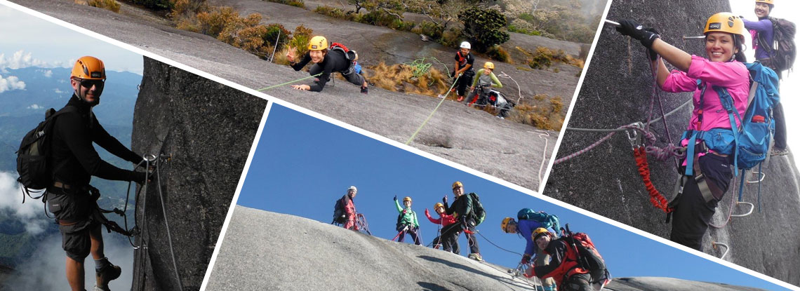
WHAT IS VIA FERRATA
A via ferrata (or ‘iron road’ in Italian, plural via ferrate) is a protected mountain pathway consisting of a series of rungs, rails, cables and bridges embracing the rock face. It allows access to scenic sections of the mountains that are typically available only to rock climbers and mountaineers.
The excitement, scenic beauty and personal conquest you will experience on a via ferrata is guaranteed to give you an invigorating nostalgic experience for years to come.There are more than 300 via ferrata routes around the world predominantly in Italy, Germany, France, Austria, Slovenia, Switzerland and Spain, and a few places in the United States and Canada.
The world’s highest via ferrata, Mountain Torq – which also happens to be Asia’s first – can now be found on Mt Kinabalu in Malaysian Borneo.
WHAT IS MOUNTAIN TORQ
Mountain Torq is the World’s highest via ferrata and Asia’s first via ferrata located at Mt Kinabalu’s Panar Laban rock face. It starts at 3,400m and ends at 3,800m – the next highest via ferrata is found in the Italian Dolomites called the Marmolada West ridge, at the highest point of 3,343 meters.
VIA FERRATA CLIMBING
An Activity for Everyone
The Mt Kinabalu via ferrata is devised to give climbers with little or no climbing experience access to rock faces normally reached by mountaineers and rock climbers. The minimum requirements needed for the first time via ferrate climber are:
- Average fitness level (Able to hike up to 3,200m in 6 hrs)
- At least 10 years old and 1.3meters tall
- Do not have a fear of heights or are willing to conquer their fear of heights
The Mt Kinabalu via ferrata routes are designed with beginner and intermediate climbers in mind.
- There is a via ferrata route to match everyone’s ability and endurance.
- Beginner climbers can take their first experience along the granite walls of Mt Kinabalu. A journey of 2 to 3 hours.
- Intermediate climbers embark on a 4 to 5 hours journey to experience the challenge of mountaineering and the lesser seen side of the mountain’s breathtaking heights and sights.
- The diversity of via ferrata routes means there is something for everyone – whether he or she is 10 or 70, a keen mountaineer or a casual holidaymaker.
No mountaineering experience Don’t worry!
There is always an experienced via ferrata trainer to lead the way. With over 1km of carefully planned out activity routes, Amazing Borneo Tours via ferrata participants can now enjoy the full experience of mountaineering in a safe and controlled environment.
MOUNT KINABALU VIA FERRATA ADVENTURE ROUTES
Walk The Torq
(Grade: French PD, Italian 2A)
At 3,520m above sea level (a.s.l), this is an introductory route designed for the beginners. It is a leisure 2 – 3 hours climb offering the thrill of walking above the clouds and dramatic bird’s eye view of mountain vistas, while being securely fasted to the side of the mountain. Reward yourself, as you feel your spirits soar with the spectacular views.
Key Facts
- Highest point at 3,520m a.s.l.
- Length of route 430m
- Vertical height traverse 109m
Highlights
- 2 cable Monkey bridge
- Tyrolean traverse
- Balancing beam
Designed For
- Groups with a range of ages
- Minimum age of 10yrs old
- At least 1.3 meters tall
- The young at heart who is game for everything!
Packages
- 2D1N MOUNT KINABALU CLIMB WITH VIA FERRATA (WALK THE TORQ)
- 3D2N MOUNT KINABALU CLIMB WITH VIA FERRATA & HIGHLAND RESORT STAY (WALK THE TORQ)
Low’s Peak Circuit
(Grade: French AD, Italian 3C)
Explore nature’s wonders from Low’s Peak Circuit at 3,776m above sea level (a.s.l.). Get glimpses of the uncommonly seen hidden corners of the mountain plateau as well as the broad and stunning landscapes surrounding the mountain. Designed for the brave and active with above-average fitness levels, this 4 – 6 hour route with an optional summit attempt includes rest stops at scenic locations.
Key Facts
- Highest point at 3,776m a.s.l.
- Length of route 1.2km
- Vertical height traverse 365m
Highlights
- (Possibly!) World’s highest suspension bridge at 3,600m a.s.l
- (Maybe!) One of the world’s highest Nepalese bridge at 3,580m a.s.l
- Connects to Walk the Torq route, so that you don’t miss anything!
Designed For
- Those who want to do it all
- Minimum age of 16 years old
- Adventure seekers looking for the challenge of attempting the summit of Mt Kinabalu and experiencing the world’s highest via ferrata all within 12 hours.
Packages
- 2D1N MOUNT KINABALU CLIMB WITH VIA FERRATA (LOW’S PEAK CIRCUIT)
- 3D2N MOUNT KINABALU CLIMB WITH VIA FERRATA & HIGHLAND RESORT STAY (LOW’S PEAK CIRCUIT)
ACCOMMODATION FOR VIA FERRATA CLIMBERS
Pendant Hut
Located at 3,289m on the Panalaban Base Camp rock slab, Pendant Hut is a cozy and eco-friendly alpine lodge reserved exclusively for via ferrata climbers. Bear in mind that it only has dormitory-style beds or a private room for 4 persons. The private room comes with an extra charge. Send your enquiry to contact@sgtrek.com for more details on room charges. Pendant Hut is unheated but one good thing is all beds come with sleeping bags.
Check-in Time :2.00pm – 4.00pm
Check-out Time :Before 12.00pm
Things to do at Pendant Hut
You can enjoy your post-midnight supper and American breakfasts, relax at the comfortable lounge area, pick up a climbing book at the mini alpine library or have fun playing board games. From here you can try to spot your Via Ferrata pals on the Panar Laban rock face! All dinner will be at Laban Rata’s restaurant which is only a short walk away.
Mandatory Briefing at Pendant Hut
All via ferrata climbers our required to attend the MANDATORY pre-activity briefings held BETWEEN 3PM and 4PM DAILY at Pendant Hut.

To ensure your own safety and that of the team, and to make the climb an enjoyable and fulfilling one, it is advisable to bear in mind the following:
- Overnight in Kinabalu Park or Kundasang Highlands (1500m a.s.l) prior to climb allows you to acclimatize to altitude changes and reduce AMS while climbing
- Engaging a mountain guide is compulsory for yourself or your group (Ratio of Max 5 climbers to 1 mountain guide)
- Wear comfortable trekking or running shoes with a good grip
- Have enough warm clothing for the summit climb
- You should feel comfortable and be able to move freely in what you wear (Denim jeans not recommended)
- Try to pack your climbing bag at around 4-8Kg (Do not bring too many unnecessary things)
- Do not have a heavy breakfast prior to the climb
- Try to finish your packed lunch within 1-2 hours from the start of the ascent (To reduce weight)
- For any special meal diet such as vegetarians, please inform our Amazing Borneo Tours consultants for arrangement
- Some chocolate & energy bars may be satisfying
- Trek at a normal pace (Too fast may result high altitude sickness & vomiting, too slow will drain out your energy)
- Rest longer at 4th or 5th KM mark – about 10 mins for high altitude acclimatization
- Should you feel too tired to carry on, try not to sit or lay down on high altitude, just stand still
- Untreated fresh mountain water is available at every shelter; you may refill them at these stops (Bring some water purification tablets)
- Boiled water for drinking or refill is available at Pendant Hut. However, it is not available at Laban Rata Restaurant.
- Be extra careful with your steps during the wet spell
- Do not run at any time while ascending or descending the mountain
- Do not run at the summit especially around the 7.4 KM mark (Most dangerous point)
- Cover your nose (and mouth) with a scarf in windy condition on high ground
- Make extra sure your feet and hands are warm and dry during the final ascent
- When descending, try to walk sideway or in a zig-zag way to prevent slipping and reduce pain on joints
- Do not bring valuable items
- Fit Climber trekking duration (3 to 4 hrs) from Timpohon Gate to Mountain Hut (Panalaban Base Camp)
- Average Climber trekking duration (5 to 6 hrs) from Timpohon Gate to Mountain Hut (Panalaban Base Camp)
- Unfit Climber trekking duration (7 to 8 hrs) from Timpohon Gate to Mountain Hut (Panalaban Base Camp)
- Bring extra Ringgit Cash (No Credit Card available at Panalaban Base Camp)
- Trekking Pole available for sale (MYR 45) at Amazing Borneo Help Desk @ Kinabalu Park
- Laban Rata Restaurant OPEN 7.00am and CLOSE at 7.30pm (No Food available after 7.30pm)
- Laban Rata Grocery Counter Closed at 7.30pm (Selling À la Carte Food, Beverages, Chips, Chocolate Bar, Batteries…etc)
- Laban Rata (Non-Heated Dormitory Rooms, Blanket, Bed, Bed Sheet and Pillow provided )
- Pendant Hut (Non-Heated Rooms, Sleeping Bag, Bed, Bed Sheet and Pillow provided)
- There will no health checks conducted by any authorities during climb registration, so climb at your own risk
It is important that you are well prepared and equipped for the climb to ensure maximum comfort and enjoyment. The average temperature range at Kinabalu Park is 15°C-24°C, along the Timpohon – Summit trail is about 6°C-14°C, and sometimes drop to as low as 2ºC in the wee hours of the morning! As for the weather on the mountain, it can range from sunny to misty to foggy. This is meant to be a good guide to help you in packing for your Mount Kinabalu Climb Trip.
MOUNT KINABALU WEATHER
The best period to climb the mountain is from March to September, as the weather during these months are considered dry. The temperature at the summit of Mount Kinabalu (4,095.2m) drops to freezing 0 °C , Timpohon to Panalaban ranges from 6 °C – 14 °C and Kinabalu Park (foot of mountain) is around 15 °C – 24 °C. Expects passing showers in the mid afternoon as you climb the mountain as it is after all a tropical rainforest and tends to receive higher rainfall.
ENGAGING A POTTER FOR YOUR CLIMB
To engage a porter is fully optional. However should you really require a porter to carry your belongings for you, we suggest that you pack a separate waterproof backpack (for easy carrying by the porter) ready with items that you do not need during the climb to Laban Rata. Porters may not trek at the same speed as you. Their job is simply to carry your belongings to the mountain hut. Valuables, water, medication, snacks, and things that you will need during your hike should always be kept with you. You may engage the porter at Kinabalu Park itself during your climb registration and the porter fees will be payable directly to the porter.
PORTER FEES
| Destination | Weight (kg) | Rate |
| Timpohon – Laban Rata | 10 | RM65.00/way |
| Laban Rata – Timpohon | 10 | RM65.00/way |
| Timpohon – Sayat Sayat | 10 | RM75.00/way |
| Sayat Sayat – Timpohon | 10 | RM75.00/way |
| Timpohon – Summit | 10 | RM80.00/way |
| Summit – Timpohon | 10 | RM80.00/way |
** Minimum weight is 10 Kgs and additional weight will be charged based on daily rate per Kg
IMPORTANT NOTES FOR CLIMBERS ON MOUNT KINABALU
- Identify your Mountain Guide who will display an identification card.
- Travel together in your own group and stay with the Mountain Guide at all times.
- Follow the instructions of your Mountain Guide.
- Alert your Mountain Guide if you face any difficulty.
- Believe It or Not, DO NOT SHOUT, SCREAM or CURSE the mountain at any point of time.
- Display your climbing permit and show it to Park Officials at the check point at Timpohon Gate, Laban Rata and Sayat-Sayat on your way up and down.
- If for any reason, you are separated from your group or the Mountain Guide, please follow the white rope that marks the summit Trail. If visibility is very low or in the dark please hold onto the rope and follow it. (There is a thick white rope leasing all the way from the vegetation belt above Panar Laban to the summit. Use this rope to help climbing up and prevent falling when walking down. PLEASE FOLLOW and USE THE ROPE FOR YOUR OWN SAFETY.
- The weather on the Summit area can deteriorate in a matter of minutes. Thick mist may reduce visibility to only 3 meters, and rainstorms and wind of up to 120 km/hr. may occur at times. Please hold on to the ROPE, which will lead you to safety.
- If you are separated from your Mountain Guide and lose sight of the ROPE, STOP IMMEDIATELY, stay where you are and blow your whistle to attract attention. PLEASE DO NOT TRY TO FIND YOUR WAY OUT. HELP is definitely on the way. The Park Officials at Sayat-Sayat check point will notice that you are missing.
- While climbing to the Summit please make sure to carry with you the followings:
Wear enough warm clothing (temperature can be freezing at times) A head torchlight (to light your way during pre-dawn climb and to signal for help when needed) A rain coat (to protect you from rain and wind, and it will slow down the loss of body heat) A whistle (only to be used when help is needed. Three short blasts to attract attraction, long continuous blasts for emergency and serious injuries) Some energy food and water (e.g. extra chocolate, glucose tablets, biscuits) (for emergency-use when you are waiting for help to arrive)
VIDEO TIPS AND TUTORIALS
HEALTH PREPARATION FOR CLIMBERS
SPECIAL NOTE FROM SABAH PARKS AUTHORITIES & AMAZING BORNEO TOURS!
It is recommended that all climbers should have themselves medically checked before attempting any mountain climb. DO NOT CLIMB If you are suffering from or have a history of the following ailments
- Hypertension
- Diabetes
- Palpitation
- Arthritis
- Heart disease
- Severe Anemia
- Peptic ulcers
- Epileptic Fits
- Obesity (Overweight)
- Chronic Asthma
- Muscular Cramps
- Hepatitis (Jaundice)
- Any other sickness or disease that may be triggered by severe cold, exertion, and high altitude.
Climbing Mount Kinabalu is usually a “once in a lifetime” experience for most people, so it is vital that proper preparations are made beforehand. With superior information and sufficient time to prepare, you stand an extremely good chance of reaching the summit.
HEALTH REQUIREMENTS
Although the majority of routes leading to the summit of Kinabalu require no technical climbing skills, some kind of training beforehand is important. It is important to remember that you will be hiking on surfaces with varying angles which may put lots of stress on your ankles and knees. It is also worth remembering that most of the injuries which occur on Mount Kinabalu happen on the way down. When climbing Mount Kinabalu, take a slow pace to allow your body to acclimatize to the altitude, as at 3000 meters, you only have 70% of the oxygen you would normally have at sea-level
To climb Mount Kinabalu
- You need to be in decent physical condition.
- You must not have heart or lung problems.
- You need healthy knees and ankles.
- Take your time and know your physical limitations.
Consult your personal physician if
- You are taking any kind of medication.
- You have any other health problems.
If you plan to take any medication during your climb, you must consult your doctor prior to departure. The effects of medications may vary with altitude and stress. All climbers should consult their doctor or a specialized travel clinic well in advance of their trip.
GROCERY COUNTER (LABAN RATA RESTHOUSE)

À la Carte All Day Dining
Food and beverage items are available at the Grocery Counter.
The menu and price list is provided below for your reference.
| Food Categories | Food Menu | Price (Nett) |
|---|---|---|
| Soup | Cream of Mushroom Cream of Chicken Tom Yam Soup | RM 19.00 RM 19.00 RM 19.00 |
| Fried Rice | Chinese Style | RM 19.00 |
| Porridge | Choice of chicken or egg | RM 19.00 |
| Noodle / Mee Hoon | Choice of dry / wet or soup | RM 19.00 |
| Instant Noodle | Choice of chicken, curry or laksa flavour | RM 12.00 |
| Sandwich Variety | Choice of tuna, egg, cheese French fries | RM 19.00 RM 19.00 |
| Buffet Categories | Food Menu | Price (Nett) |
|---|---|---|
| Buffet | Supper (02:00hr-03:30hr) Breakfast (07:30hr-10:30hr) Dinner (16:30hr-19:00hr) | RM 40.00 RM 55.00 RM 75.00 |
| Beverage Categories | Beverage Menu | Price (Nett) |
|---|---|---|
| Hot Drink | Tenom Coffee Milo Sabah Tea Nescafe Horlicks Lemon Tea Hot Ginger Tea | RM 12.00 RM 13.00 RM 13.00 RM 11.00 RM 13.00 RM 13.00 RM 13.00 |
| Soft Drinks | 100 Plus Coke Light Coke Soya Beans F&N Strawberry F&N Orange Sprite Drinking Water 500ml Drinking Water 1.5L | RM 11.00 RM 11.00 RM 11.00 RM 11.00 RM 11.00 RM 11.00 RM 11.00 RM 7.00 RM 14.00 |
** All items are available from 10.30 am until 7:00 pm.
Other Items Available at Laban Rata Grocery Counter include:
- Batteries
- Cigarettes
- Oral Medications such as Paracetamol
- Eye Drops & Ointment
- Chocolates, Biscuits & Chips
- Sanitary Pads
- Tissue Paper
- Combs & Toothbrush
- Disposable shavers
- Body Lotion
- Lip Balm
- T-shirts
- Gloves & Beanie/Winter Hat
- Disposable Raincoat/Ponchos
- Portable Oxygen Inhaler
** Please note that the items in this list are not comprehensive and not always readily available. This list serves as a guideline only. Please ensure you bring your own necessary items up the mountain if that is considered important to you.
THINGS TO BRING
It is important that you are well prepared and equipped for the climb to ensure maximum comfort and enjoyment. The average temperature range at Kinabalu Park is 15°C-24°C, along the Timpohon – Summit trail is about 6°C-14°C, and sometimes drop to as low as 2ºC in the wee hours of the morning! As for the weather on the mountain, it can range from sunny to misty to foggy. This is meant to be a good guide to help you in packing for your Mount Kinabalu Climb Trip.
THINGS TO PACK FOR MOUNTAIN CLIMB
TIMPOHON / MESILAU GATE >> PANALABAN BASE CAMP / PENDANT HUT (1st ASCENT)
(Day Climb / Weather: Usually Warm and Sunny)
- Wear lightweight clothing like t-shirts and track pants.
- Wear covered walking/hiking shoes with good grip. (Sports shoe is adequate).
- Waterproof backpack to store your items. (If not, buy a rain cover for your backpack. Try to limit it to less than 6 kg. It would be a burden for you to bring more than that)
- A small lightweight towel
- A 500ml drinking water will be provided with your packed lunch.
- Refillable 1 – 1.5 litre water bottle. (Most climbers need only about 1.5-2L of water till Panalaban Base Camp)
- High energy food such as chocolates, nuts, biscuits, sweets, energy bars.
- Trekking/Hiking Pole (Can be purchased from Amazing Borneo Help Desk in Kinabalu Park at MYR 45/pole, simply inform our staff)
- Personal toiletries such as soap, toothbrush and toothpaste.
- Change of clothes and extra socks for sleeping.
- Ponchos or Disposable Raincoat (2-3 sets) or waterproof jacket in case of rain.

PANALABAN BASE CAMP / PENDANT HUT >> LOW’S PEAK SUMMIT (02:00hrs 2nd ASCENT)
(Night Climb / Weather: Usually Cold and Windy)
Your day pack with extra belongings can be kept at your room without additional charge.
- Warm clothing is essential
- Waterproof Wind breaker
- Fleece jackets, long sleeves shirts, thick trousers/hiking pants, thick socks and good shoes.
- Head Torch. (Head torch is necessary as most of the time you have to hold the rope in the dark).
- Cap / Beanie / Head Scarf /Balaclava mask. (It will keep warm and protect your head and face from the cold wind).
- Gloves. (Waterproof gloves is the best, It will protect your hands from rope burn and cold).
- Small water bottle (500ml bottle is enough).
- Ponchos or Disposable raincoat or waterproof jacket in case of rain.
THINGS YOU WISH TO BRING
- Medication such as painkiller or altitude sickness tablets, etc.
- Toilet tissue papers.
- Sunglass, sunblock lotion, SPF lip balm, plasters
- Insect repellent
- Camera with waterproof bag
- Rubber sandals/slippers. (It can be used in the wet bathroom during your stay in Mountain Hut).
- Plastic bags.
- Waist pouch. Waist pouch is handy during the second part of the climb as you could keep your camera and raincoat inside.
NOTE: SLEEPING BAGS ARE NOT NEEDED!!!
Decide on the things that you want to bring up the mountain and then halve it. This is really what you need. Most important rule in packing for mountain climb is – travel light.
You can store your belongings and luggage before the climb at the Kinabalu Park HQ reception. Just pack the necessities mentioned above in your waterproof backpack for the climb. However, if you are in need to hire a porter to carry your backpack, below is the porter fees payable to Kinabalu Park HQ.
PORTER FEES
| Destination | Weight (kg) | Rate |
| Timpohon – Laban Rata | 10 | RM65.00/way |
| Laban Rata – Timpohon | 10 | RM65.00/way |
| Timpohon – Sayat Sayat | 10 | RM75.00/way |
| Sayat Sayat – Timpohon | 10 | RM75.00/way |
| Timpohon – Summit | 10 | RM80.00/way |
| Summit – Timpohon | 10 | RM80.00/way |
** Maximum weight is 10 Kgs and additional weight will be charged based on daily rate per Kg
FAQ
Where Is Mount Kinabalu
Mount Kinabalu (Gunung Kinabalu/Akinabalu) dominates the island of Borneo in South East Asia. It stands poised in the East Malaysian state of Sabah, and is protected as Kinabalu National Park, a UNESCO World Heritage Site.
When Is The Best Time To Climb Mount Kinabalu How Is The Weather In Mount Kinabalu
The best time to climb Mount Kinabalu, 4,095 metres (13,435 ft) is during the dryer seasons which falls around March to September. The weather is slightly unpredictable with passing showers expected all year round as it is a tropical rainforest. The temperature at the summit of Mount Kinabalu drops to freezing point 0 °C – 3°C, whereas the trail from Timpohon to Panalaban basecamp ranges from 6 °C – 16 °C and before the start of the climb is around 15 °C – 26 °C at Kinabalu Park.
What Is The Maximum Number Of Climbers Allowed Per Day And Why
Currently, Sabah Parks only issue 175 climb permits daily, but this number may change in future. This is mainly because of safety reasons in overseeing climbers’ safety upon ascending to Low’s Peak summit in total darkness. It is also to ensure the summit climb is not overcrowded by climbers.
Who Can Climb Mount Kinabalu Any Age Limit
There is no age limit for who can climb Mount Kinabalu, as long as you are in good shape, good health status or you have sought approval from your doctor if you are on any medication. Amazing Borneo Tours has served thousands of climbers ranging from 7 to 80 years old. We do however, suggest young children to be at least 10 years old due to numerous steps and steep slopes. Similarly, elderly climbers need to be in good health and fitness level to attempt the climb.
Do I Need Any Special Skills Or Equipment For The Climb
Not at all. Climbing Mount Kinabalu is indeed a big adventure, but no climbing skills or equipment is needed. Climbing Mount Kinabalu involves several flights of stairs, just being equipped with a good pair of trekking shoes, waterproof jacket, head torch and gloves is enough to get you far. Anyone reasonably fit and healthy can scale, hike, trek and climb with confidence. Regular exercises will give you an added edge in attempting a successful climb. suggest young children to be at least 10 years old due to numerous steps and steep slopes. Similarly, elderly climbers need to be in good health and fitness level to attempt the climb.
How Do I Hire A Porter
Please inform us upon confirmation of your booking if you may require a porter. We will arrange for a porter to standby at Kinabalu Park HQ on the morning of your climb to assist you. All payments are made directly to the porters in cash.
What Is The Cost Of Hiring A Porter
Porter Fee (OPTIONAL)
| Destination | Weight (kg) | Rate |
| Timpohon – Panalaban | 10 | RM65.00/way |
| Panalaban – Timpohon | 10 | RM65.00/way |
| Timpohon – Sayat Sayat | 10 | RM75.00/way |
| Sayat Sayat – Timpohon | 10 | RM75.00/way |
| Timpohon – Summit | 10 | RM80.00/way |
| Summit – Timpohon | 10 | RM80.00/way |
** Minimum weight is 10 Kgs and additional weight will be charged based on daily rate per Kg
** All rates are inclusive of 0% GST.
** Rates stated are for reference purposes only. Please confirm with porters on their day of services.
** All payments are made directly to the porters in cash.
Will The Porters Trek Along With Me
No. Porters will carry your belongings and walk non-stop to Panalaban base camp and wait for your arrival. They will not trek together with you nor wait for you at each stop. Therefore, please do not ask them to carry items that are considered handy to you during your climb.
The best tip is to pack 2 separate bags; one is for the porter to carry straight to Panalaban, the other personal bag containing your necessities (e.g. water, lunch pack, energy bars) will be carried by you throughout the climb. Remember to keep it light.
Who Can Climb A Via Ferrata
Almost anyone. Climbers and non-climbers aged between 10 and 70 who are fit and healthy, not afraid of heights, and want to experience the mountain in a whole new way. Oh and by the way, you also have to be at least 1.3m tall
Can I Climb Mount Kinabalu Without A Guide
No. Even though you are an experienced climber, Sabah Park safety regulations require all climbers/hikers to be accompanied by a licensed mountain guide from the local Mountain Guide Association. The ratio is at least 1 mountain guide to a maximum of 5 climbers (more than 16 years old) and 1 mountain guide to a maximum of 2 climbers (less than 16 years old).
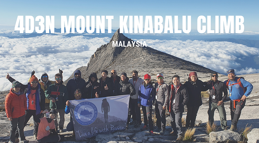
UPCOMING EVENTS 2023
4D3N MOUNT KINABALU CLIMB 2023
DOWNLOAD OUR TRAINING PROGRAM:
SGTREK – Kinabalu Training Plan
For any queries related to the event do contact below person:
Phone: +65 92700908 (WhatsApp)
Email : contact@sgtrek.com
This trip is organized by:
SGTREK PTE. LTD.
Reg. No. 201816267K
STB License No. 03160
Address: 28A, Kandahar Street
Singapore 198889
Email: contact@sgtrek.com
WhatsApp: +6592700908
Website: https://sgtrek.com
You can leave your contact if you are interested to know more about the trip.


Very useful guide indeed and a great aid in helping arrange and organise for my upcoming Kinabalu trek in March. Thank you
Thank you very much. If any queries regarding the climb feel free to check with us.
Hi,
Do you also have a trip to Mount Rinjani, Indonesia? We are open for partnership.
We have rinjani partner thank you.